Sawmills were a common sight in many villages across Quebec in the 19th century. The Township of Rawdon was no exception. Indeed, a sawmill built on the first range by Philémon Dugas and his partners marked the start of the township’s development. Most of these mills were powered by water. The equipment consisted of a single reciprocating saw and a manual log-feeding mechanism. This equipment was housed in a building with a relatively simple structure. They produced planks and boards for the local market. The logs were sawn very slowly, and production rarely exceeded a few hundred planks or boards a day. For the most part, these mills operated part-time and on a seasonal basis. Often situated alongside a flour mill, these mills became the focal point of villages or emerging settlements.
Several mills have been built on the Rouge River in Rawdon township since its creation in 1799. The Rouge River crosses Rawdon township upstream from lot 28 of the eleventh range (bordering Saint-Alphonse) to what was lot 27 of the township’s first range (now on the territory of Saint-Liguori).
This article identifies five sites that were suitable for the construction and operation of mills on the Rouge River. For each of these sites, the article describes the people or families responsible for their construction and subsequent operation. Where available, various technical characteristics of these mills are provided.
The Rouge River is the largest tributary of the Ouareau River. Its confluence is located in the municipality of Crabtree. Estimates by specialists (1, 2, 3) put the average flow at the outlet of Rawdon Lake at around 1.91 m³/second. The flood flow is estimated at 7 m³/second, while the flow during the low-water period (July to October) is assessed at only 0.7 m³/second. These flows are ten times lower than those of the Ouareau River.
There are a number of factors that influence the choice of a site for the construction of a water-powered mill. In simple terms, it must first be recalled that the power generated by the water varies according to flow rate and head. The chosen site must also facilitate the supply of raw materials (logs and grain) and have a customer base that needs the processed products (planks and flours). With the means of transport available at the time, it is highly likely that the first mills served a nearby territory.
These five sites are presented from downstream to upstream, starting with the one located on Range 1 in Rawdon township.
Site no. 1 — Lot 24 — Range 1 — Dugas mills
Site no. 2 – Lot 20 – Range 4 – Burns / Bordeleau / Desrosiers / Breault Mill
Site no. 3 — Lots 18 and 19 — Range 5 — Dugas / Truesdell / Lord / Copping / Mason / Neveu mills
Site no. 4 — Lot 22 — Range 7 — Hobbs / Bagnall / Munroe mills
Site no. 5 — Lot 28 — Range 10 — Desrochers / Cornellier / Mason mill
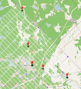
This screenshot comes from an interactive map, the Carte historique du Canton de Rawdon. Drawn using the Umap/Openstreetmap tool, it can be accessed by clicking on this link . The red push pins identify the sites on the Rouge River.
Site no. 1 — Lot 24 — Range 1 — Dugas mills
These mills were located near Route 346 (“Montcalm corner”) and the Montcalm Golf Club.
A genealogical study (4) of the first families to settle in Rawdon, conducted by Daniel Parkinson, reveals that the first rights of occupancy were issued to various immigrants having come mainly from Ireland.
Daniel Parkinson reports that a certain Joseph Dugas, an Acadian from Massachusetts, indicated in his application for a grant that he had been a resident of Rawdon township since 1816. The road he traced to his land provided the first access to the territory. His brother Philémon (sometimes identified as Philémon Firmin) followed him and, between 1816 and 1817, built a sawmill on lot 24 of Range 1.
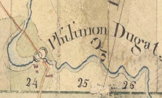
In 1820, thirty families were granted the right to settle in Rawdon by government decree (Order in Council). Philémon Dugas obtained his ticket of location in November 1820. The site of this mill is shown on the map of Rawdon and Kildare townships prepared by Joseph Bouchette Junior, dated October 31, 1821.
The Dugas family
To build his mill, Philémon enlisted the help of Isaac Dugas and his brother-in-law Pierre Richard, married to Isaac’s sister Félicité. Alexandre Riopel tells us, in an article published in 2014 in Histoire Québec, that the grandfathers of Isaac and Philémon, two brothers named Joseph and Claude were millers at the flour mill on the Achigan River and the lower mill owned by the Sulpicians. Philémon, Isaac and Pierre formalized their partnership in February 1817. In the same notarial deed (5), Pierre Richard agreed to cede lot 24 to the partnership. This partnership was short-lived. In June 1817, the partners agreed (6) to dissolve the partnership and sell the mill and lot 24 to Philémon Dugas. The deed also transferred the right to place a millstone to grind grain in the sawmill. Philémon Dugas and his wife subsequently, that is, between March 1818 and March 1820, partnered with Martin S. Parker (7).
Documentation presently available does not identify the person who sold lot 24 to Pierre Richard. There may have been other owners before Pierre Richard, but James Sawers, who died in 1813, was the first owner of this lot. He obtained 500 acres, that is, the northeastern half of lot 21, as well as lots 22 and 24 of Range 1, by letters patent dated July 13, 1799 (8).
To this sawmill, Philémon added, a few years later, a flour mill (grist mill), so that by the 1825 census (9), he owned both mills. Daniel Parkinson points out that Mr. Dugas made considerable improvements to his facilities. His house measured 36 by 30 feet, while his mills were 32 by 66 feet. The flour mill had three sets of stones. Two of these were used to produce wheat flour for export. The other was used to produce oat flour. The sawmill had two sets of saws. A fire that occurred during the night of December 31, 1829 (10), destroyed Philémon Dugas’s flour mill and sawmill, causing losses estimated at 1,500 pounds. The mill would, however, be rebuilt.
Family succession
Meanwhile, the Philémon/Firmin family grew, with the birth of at least nine daughters and one son. They also adopted John Copping, born around 1812 and still a minor at the time Philémon Dugas and his wife wrote their wills (11). The son, born on March 8, 1830, was named Firmin and was to take over the business. Philémon Dugas’s extended family would also contribute to the operation of the mills. The eldest, Bibiane, took Zacharie Clouthier as her husband. Philémon’s son by adoption, John Copping, first worked as an apprentice, then married Julie (1811-1872) in 1837. Adaline (1814-1873) married Daniel Truesdell in 1835. Finally, Anne (1822-1908) united her destiny with that of William Lord in 1846.
According to Daniel Parkinson (12), it is plausible that Philémon Dugas remained the owner of these mills until his death on July 19, 1864. Very early on, however, Philémon’s sons-in-law and sons played an active role in the operation of the mills in Rawdon and the surrounding area. The Copping family operated mills in Rawdon until the middle of the 20th century. The 1852 census mentioned that the flour mills then had a production capacity with four sets of stones....which suggests that the Dugas family operated mills on more than one site.
A contract (13) drawn up before notary S. Ulric Brien dit Desrochers concerning a financial transaction (loan and mortgages) confirms the business relationship between Firmin Dugas, the son, and John Copping. In this contract, Firmin Dugas was identified as Esquire and bourgeois, while John Copping was identified as a miller. This deed also showed that Firmin Dugas owned lot 24 of Range 1 with the flour mill, while John Copping owned the southeast quarter of lot 18 of Range 5 with the sawmill and flour mill.
Established as a Catholic parish in 1853 (March 16), Saint-Liguori received its civil recognition in 1880 (June 26). Lot 24 of Range 1 will be part of the territory of the Township of Rawdon annexed by decree dated May 9, 1854 to the parish of Saint-Liguori.
Firmin Dugas, the son, died suddenly on March 16, 1889, at the age of 59, such that the mill was abandoned while a succession involving several lots and minor children was settled. Jean Gagnon, a Saint-Liguori historian, continued the story as follows (14):
“Later, around 1900, the water power was sold by Louis Dugas, Member of the Provincial Parliament, son of Firmin, to his cousins Sam, Georges and William Lord; they completely rebuilt the two mills and dug a canal over a distance of 7 arpents (about 400 metres) to carry water from the Rouge River. The mills were back in operation by September 1902 (p. 22).
“...the corn and buckwheat flour mill was gradually abandoned, but the sawmill continued to run. It was sold to a man named Chicoine during the “depression,” but he had to return it for lack of payment. Mr. Alcide Lévesque, the current owner, bought it from Georges Lord in 1938 (p. 138).” [Translation]
Jean Gagnon concluded by pointing out that, reportedly, this mill was still powered by water in the 1950s, produced an average of one million feet of wood per year and was in operation until the fire of 1976.
GEOGRAPHICAL COORDINATES
Lot 24 – Range 1
46.0543⁰ N 73.6859⁰W
These approximate coordinates need to be validated by field surveys.
Site no. 2 – Lot 20 – Range 4 – Burns / Bordeleau / Desrosiers / Breault Mill
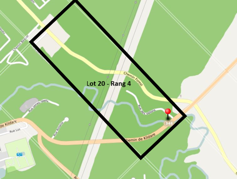
This sawmill was situated on Lot No. 20 of the fourth range in the township of Rawdon, placing it near the bridge crossing the Rouge River at the start of Chemin de Kildare close to Chemin Forest.
The list of concessions available on the website of the Office of the Surveyor General of Quebec (see references) identifies the first owners of Lot No. 20. The north-western half (100 acres) was granted to George Copping, with letters patent issued on 18 December 1834. As for the south-eastern half (100 acres), it was granted to Patrick Byrne. The letters patent were issued on 22 May 1832.
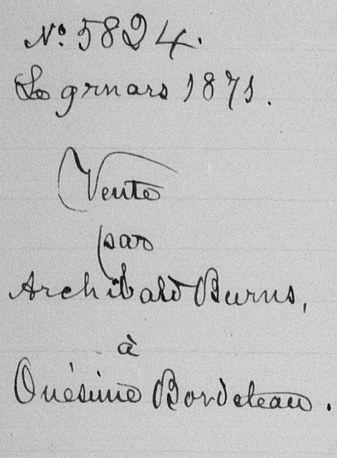
A notarised deed signed before Maître Jules Bourgeois on 9 March 1871 records the sale of a plot of land on Lot 20, Range 4, including a sawmill on the Rouge River.
This deed of sale between Archibald Burns and Onésime Bordeleau states that the plot measures ‘one and a half arpents in width by two arpents in depth’. It is bounded at the front, rear and north by the land of the seller, Archibald Burns, and on the other side by the Rouge River. The deed mentions that a house and a sawmill are built on the plots of land. The transaction also included two plots of land intended to provide access to the sawmill from the public road.
Archibald Burns states that he acquired this plot of land, ‘on a larger scale’ (he purchased a larger area than he is selling), from Patrick Burns by a deed drawn up before the notary Louis Joseph Riopel on 13 June 1866.
In his book Up to Rawdon (page 69), Daniel Parkinson notes that over the years, various spellings – Burn, Burns, Byrn, Byrne, Byrnes and Byron – have been used to refer to this family from Rawdon. He also mentions that Patrick Burns is said to have had a son named Archibald, born on 12 August 1839. Although there is no conclusive evidence, it seems logical to regard the transaction between Patrick and Archibald Burns as a ‘father-to-son’ transfer. Archibald married Anna Maria Kyte on 9 April 1878. They had seven children. Archibald died in 1914 and Anna Maria in 1921. It has not, however, been possible to determine which of the two, Patrick or Archibald, built the mill.
Onésime Bordeleau’s mill was recorded in 1871. The information on file indicates that the mill was valued at $600, which was the price paid for it a few months earlier. It operated twelve months a year and required only one employee to run it. This person’s annual wage was $96. Using water power and with a capacity of 25 HP, the mill was capable of sawing 400 logs per year, worth $200, and producing approximately 3,500 planks, worth $300.
Onésime Bordeleau sold this mill on 25 August 1874 to Denis Desrosiers. The deed of sale was signed before Maître Ulric Brien dit Desrochers. The transaction included, in addition to the mill, a certain quantity of raw materials. It could have yielded a good profit for Onésime, with a sale price of $1,100. However, for unknown reasons, Onésime Bordeleau reclaimed the mill and had to sell it again. On 26 February 1879, he signed the sale of the mill to Léon Breault before Maître Jules Bourgeois for a price of $700.
The mill site
Without a map showing the mill’s precise location, it is difficult to determine the exact site of the mill on the south-eastern part of Lot 20, Range 4. However, given that the land in question comprises two acres and plots of land providing access to the mill from the public road, and assuming that this public road is Kildare Road, the mill is likely to have been built along the Rouge River, some 100 metres from Chemin de Kildare (Route 348).
Further research should make it possible to pinpoint its location more accurately and determine what became of the mill.
Site no. 3 — Lots 18 and 19 — Range 5 — Dugas / Truesdell / Lord / Copping / Barrie / Mason / Barrie / Neveu mills
These mills were situated at various locations near the site now known as Mason Falls. Having been built and rebuilt on several occasions, the sawmills and flour mills at Mason Falls enjoyed a long history.
Recent data obtained from systematic research into notarial archives carried out by Guillaume Petit has made it possible to confirm various details and to reassess certain hypotheses regarding the presence of mills near Mason Falls.
The 1851 census records indicated that Mr. Dugas then had two sawmills with five sets of saws and a flour mill with four sets of stones. He also enjoyed a privilege that gave him a monopoly on water mills on the Rouge River from lot 24 of Range 1 to lots 18 and 19 of Range 5.
Two sites at Mason Falls
Additional documentation provided by Guillaume Petit and further details supplied by Daniel Parkinson indicate that, during the first half of the 19th century, two sawmills are believed to have operated side by side at the site that would later become known as Mason Falls. One of these mills was built on the south-eastern half of Lot 18, Range 5, whilst the other was built on the south-western half of Lot 19. Further details follow.
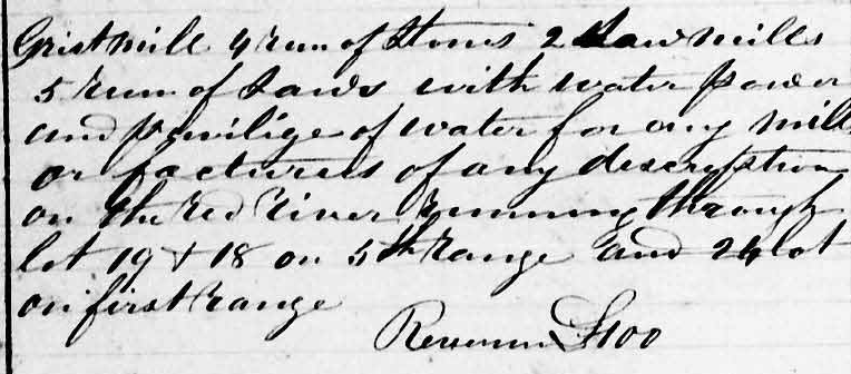
Mills and privileges
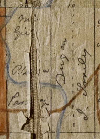
Guillaume Petit stresses the importance of this question of privilege on his website. New information, obtained in February 2026 following Guillaume Petit’s research, confirms that, by virtue of this privilege, Philémon Dugas owned mills at another location, which allowed him to achieve the declared production capacity. A more detailed technical analysis would likely demonstrate that the mill’s location on Lot 24 did not have sufficient power to justify such a production capacity. However, one or more mills situated on Lots 18 and 19 of Range 5 could have had a much greater motive power. These lots correspond to a site known today as Mason Falls. The Holtby map supports this hypothesis, as the name Dugan (sic Dugas) appears as the owner of Lot 19 of Range 5.
This new information also opens the door to another chapter in the history of the mills on Lots 18 and 19 of Range 5.
Before the Dugas
Recent information now makes it possible to trace back the history of the township of Rawdon from its earliest days. The list of land grants (see reference no. 8) identifies the first people who obtained lots in the township of Rawdon. Four families obtained lots near Mason Falls, namely:
Rang | Lot | Part | Acres | Land Grantee | Date (Letters patent) |
5 | 18 | ½ SouthEast | 100 | Solomon Cook | May 22,1834 |
5 | 18 | ½ NorthWest | 100 | Edward McGie | February 4, 1825 |
5 | 19 | ½ SouthWest | 100 | Jeremiah Pratt | May 22,1834 |
5 | 19 | ½ NorthEast | 100 | John Smiley | January 19, 1832 |
Daniel Parkinson’s book entitled Up to Rawdon and its updates available on the book’s website contain some information on these first families to live in Rawdon township. From this group, Jeremiah Pratt, a millwright, appears, at first glance, as the most likely to have been involved in the construction of a mill.
The Holtby map, developed by the secretary-treasurer of the time, contains annotations identifying the owners of the different lots around 1845. From left to right and top to bottom, a hand-written inscription on the northwestern part of lot 18 could indicate the name of McGie, that is, the original owner of the lot. The southeastern part may have already been divided and belong to a person whose name is illegible. Another section of the southeastern part of this lot seems to indicate the word “parsonage.” It would therefore have belonged to the Anglican Church parsonage. As for the southwestern half of lot 19, it appears to have belonged to a person named Dugar ([sic] Dugas), while the northeastern half appears to still belong to John Smiley.
Philémon Dugas and the sawmills on lots 18 and 19 of Range 5
The Pratt-Dugas / Truesdell mill (½ SW, lot 19, Range 5)
This information suggests that Philémon Dugas ([sic] Dugar), already the owner and operator of the mill on Range 1, acquired the southwestern part of lot 19 from Jeremiah Pratt in the years that followed the original land grant of May 1834 and installed a sawmill on this part. Different scenarios are possible (construction by Pratt and purchase by Dugas, purchase of the land and construction by Dugas, collaboration/partnership Pratt-Dugas and repurchase by Philémon). Philémon is believed to have entrusted the operation of the mill to one of his sons-in-law, Daniel Truesdell, such that, in his journal, George Copping refers to the Truesdell mill.
Daniel Parkinson cites the words of George Copping dated March 16, 1837:
“Henry took a log over to Mr. Truesdell’s to be sawn.”
Other than the name of Jeremiah Pratt appearing in the list of land grants, it has not been possible to find any documentation to confirm these assumptions.
The Cook-Rood-Dugas / Truesdell mill (½ SE, lot 18, Range 5)
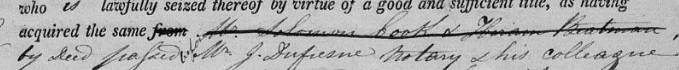
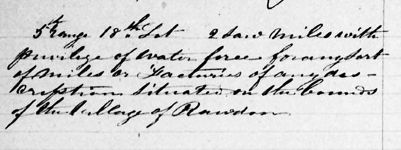
With regard to the southeastern half of lot 18, two contracts signed on August 29, 1844, and October 15, 1845, before Notary Joseph Dufresne and Notary Antoine Gauthier, respectively, contain much relevant information. The second deed of sale enabled Philémon Dugas and Daniel Truesdell (identified as lumber merchants) to jointly acquire the southeastern half of lot 18 on Range 5 (SE ½, lot 18, R5) belonging to Josiah S. Rood (also identified as a lumber merchant) on which there was an English-style double sawmill. This land measured 100 acres. One-acre parcels had already been sold to other people, including Reverend Bourns (justifying the term “parsonage” on the Holtby map). The payment of this land, sold for 300 English pounds, was guaranteed by Philémon Dugas with a mortgage in favour of the seller on the half of lot 19 on Range 5. The deed of sale specified that this half lot included a mill, a house and other buildings.
Josiah Rood had acquired this land by means of a contract signed in 1844 before Notary Joseph Dufresne. It has unfortunately not been possible to find a copy of this deed of sale. Although the names are crossed out, this property title signed before Notary Dufresne likely referred to a sale by Solomon Cook (the first holder of the letters patent) and Hiram Bateman (?).
This second mill was built between May 22, 1834, that is, the date on which the letters patent were obtained by Solomon Cook, and the date of the sale of this mill to Philémon Dugas and Daniel Truesdell (October 15, 1845). It was not built by Philémon Dugas, but the available information does not provide any indication of who did build this mill.
As of October 1845, Philémon Dugas was therefore the owner of two sawmills located near the falls now known as Mason Falls.
The 1851 census corroborates the fact that Daniel Truesdell operated his father-in-law’s mills.
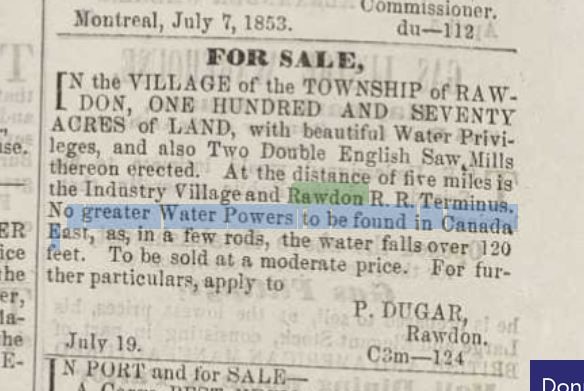
These two mills would remain the property of Philémon Dugas until 1853, when he published an advertisement in the Montreal Herald newspaper issue of July 23, 1853, by which he put them up for sale with land measuring 170 acres, that is, the 100 acres of the southwestern part of lot 19 and some 70 acres remaining from the southeastern part of lot 18.
Location of these mills
A map retrieved from the site of the Registry of the Surveyor General of Quebec delimiting the lots shows that the Rouge River runs through these lots 18 and 19 of Range 5 and crosses the line delimiting lot 18 from lot 19, all near the site of Mason Falls.
The creation of the dam and then the “bridge-dam” on 3_ Avenue changed the course of the Rouge River, such that additional information needs to be obtained to determine the exact location of these mills.
The Dugas family ties
Philémon Dugas therefore apparently entrusted the operation of these mills on lots 18 and 19 of Range 5 to one of his sons-in-law, Daniel Truesdell. Daniel Truesdell, as was mentioned earlier, married Adaline Dugas in 1835. The Commission de toponymie du Québec (15) adds that, on March 23, 1853, Daniel Truesdell obtained a lot in the township of Chertsey. He built a sawmill in 1855, which he ceded to his son Daniel in 1871. Shortly before obtaining the lot in Chertsey, that is, on February 8, 1853 (act no. 1150 – Notary Jules Bourgeois), Daniel Truesdell ceded to his father-in-law, Philémon Dugas, the share that they had jointly purchased.
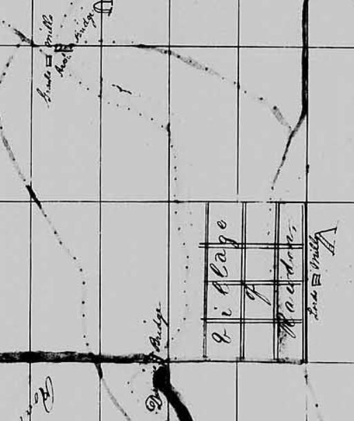
On June 17, 1854, by act no. 1483 signed before Notary Jules Bourgeois, Philémon and his wife, Martha Edwards, ceded to William Lord, a mill builder, and John Copping, a master miller, their sons-in-law, the southeastern half of lot 18 on Range 5, on which a house and a sawmill were built, and the southwestern half of lot 19, on which a house and a double sawmill were built. John Copping then reportedly ceded the mills to his brother-in-law, William Lord (1817-1860), a millwright. A hand-drawn diagram of a part of the township of Rawdon inserted in the 1861 census associated these mills with Mr. Lord (see Lord’s mills in the bottom right-hand corner of the map).
When William Lord died in 1860, John Copping apparently took back the mills that he reportedly gave as security (the southwestern quarter of lot 19 on Range 5) in different financial transactions conducted between 1860 and 1870.
The Mason and Copping mills
After marrying Mary Copping (1841-1912) on April 9, 1861, Edward Mason obtained John Copping’s mill. Edward Mason’s name appeared in the 1871 census as the owner of a sawmill and a flour mill. This census provided details of the mills owned by Mr. Mason, mentioning that these mills were worth $1,200 each and declared powers of 20 HP for the flour mill and 10 HP for the sawmill. At that time, mill technology had evolved, and it then became possible to provide these installations with much greater motive power.
The invention of the radial/circular saw blade around the mid-19th_ century allowed for a substantial increase in the daily production of these mills.
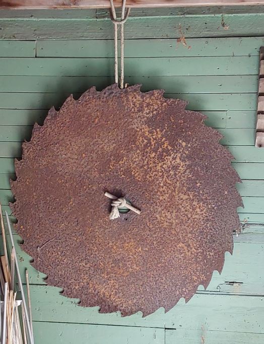
This circular saw blade was discovered by Maciej Zubek and his sister Agnieszka when they were exploring the waters of the Mason Falls in the 1980s. Young teenagers Maciej and Agnieszka, originally from Poland, were fascinated by the beauty of the land surrounding Mason Falls. Today, the blade has been entrusted to Elizabeth Chodkowski, a member of the board of directors of the Société d’histoire de Rawdon.
Daniel Parkinson provided us with a little more information on Edward Mason. Born in Saint-Sulpice on September 11, 1829, he died on August 25, 1889, leaving Mary with 375 acres of land, two sawmills, a grist mill, a flour mill, several farmhouses with outbuildings, a house with outbuildings and a house in the village (Mason family documents, as quoted in the book Up to Rawdon). This bequest corroborated the information that Edward Mason had acquired the sawmill located on lot 28 of Range 10 in Rawdon and having been owned by Jean Louis and André Brien Desrochers. Edward grew his business, such that the falls situated there now bear his name.
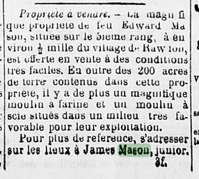
From the Mason family to the beginnings of the tourism industry
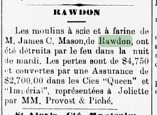
Heiress to the assets of Edward Mason, Mary Copping then ceded them to her son, James Mason, by an act dated September 24, 1890, signed before Notary Desaulniers. In the L’Étoile du Nord newspaper, James Mason Jr. advertised that the Mason family property was for sale. This “magnificent” property included 200 acres of land as well as sawmill and a flour mill. An article dated March 26, 1896, in the same newspaper reported that a fire had destroyed James C. Mason's sawmill and flour mill. The losses were estimated at $4,750 and covered by $2,700 in insurance. The mills were rebuilt.
It was not possible to identify to whom and in what year James Mason sold his sawmill and flour mill. However, on April 14, 1908, Misaël Neveu and William Barrie established the “Barrie & Neveu” company, and in so doing, pooled certain assets valued at $24,000. William Barrie contributed $12,000, including by making available to the company lot 19 of Range 5 with a sawmill and a flour mill, the machinery, a dam and the water power to operate everything. This company was short-lived, though, as on September 29, 1909, William Barrie sold the property with the mills to Misaël Neveu and proceeded to dissolve the company, as recorded in a deed of sale signed before Notary C. G. H. Beaudoin._ C. G. H. Beaudoin.
Misaël Neveu sold the mills on February 14, 1913, but continued to operate them until July 1914, as permitted in the deed of sale signed before Notary Gaspard-Alexis Archambault. With this transaction, these lands would be passed on to James Williamson Ross, a real estate developer, and would mark the beginnings of tourism in the township of Rawdon.
Location of the mills at Mason Falls
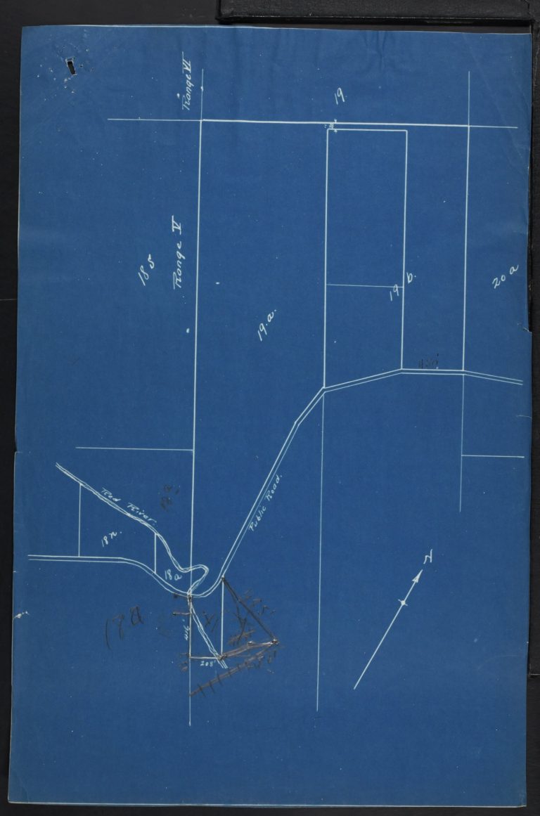
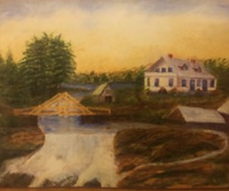
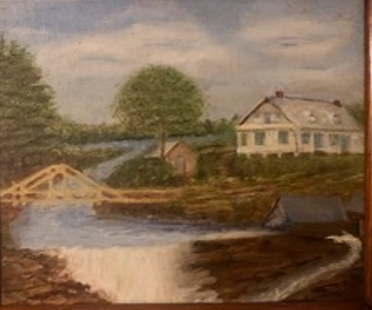
The elements that helped determine the location of the mills included the content of the deed of sale by Misaël Neveu to James Williamson Ross (act no. 8220 dated February 14, 1913) signed before Notary Archambault and two images: a painting by Sarah Alice Mason Copping and a photograph of Mason Falls.
The deed of sale identified the land parcel that was the subject of the transaction as forming a part of lot number 19a (pt 19a) of the fifth range of the township of Rawdon and described the parcel as follows:
A line starting at the west corner of the said lot number nineteen a (19 a),
- thence continuing south easterly along the division line between the lots number eighteen s (18 s) and eighteen a (18 a) on one side, and nineteen a (19 a) on the other side to a point situated at four hundred and sixteen foot beyond the public highway,
- thence at right angle in a north easterly direction a distance of two hundred and eight foot, thence at right angle in a north westerly direction as far as the public highway,
- thence following along the public highway to the division line between the lots number nineteen a (19 a) and nineteen b (19 b),
- thence along this last division line in a northwesterly direction as far as the sixth range,
- thence along the division line between the fifth and sixth range to the starting point.
A plan accompanied this deed of sale.
A painting by Sarah Alice Mason Copping depicts the family home and the Mason mill. The painting illustrates some of the installations needed to operate a mill (inlet and outlet).
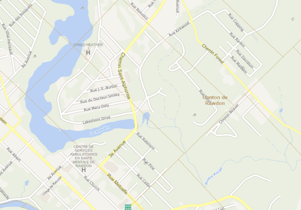
Work carried out by Yvon Laurin has made it possible to transpose the information extracted from the deed of sale onto a recent map of the municipality of Rawdon. Since 1973, Yvon has carried out numerous surveying projects in the Township and Village of Rawdon. A resident of Rawdon, he is very familiar with the municipality's territory and the area in question.
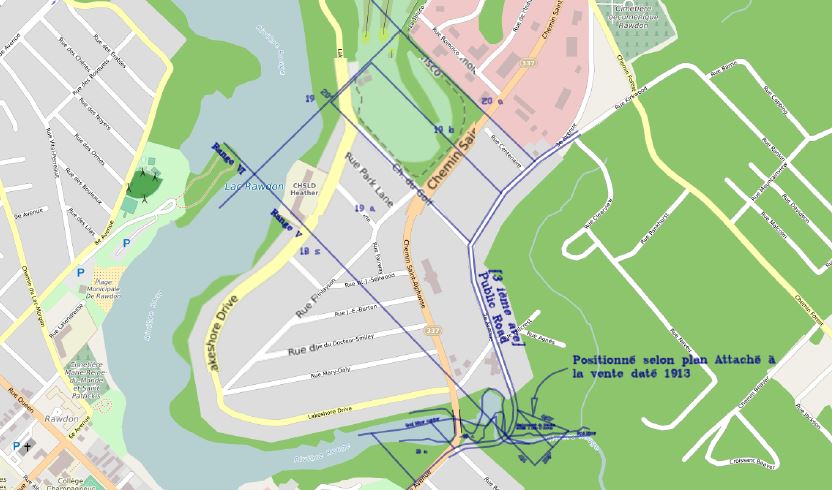
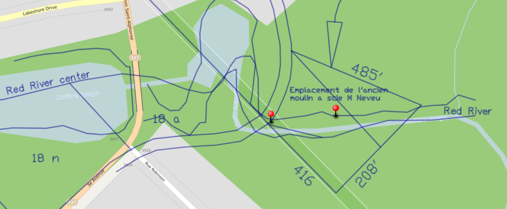
A close look at this map reveals that the public road and the former bridge on 3rd Avenue ran along a different route (much farther to the east) compared to the current one. The transposition carried out by Yvon Laurin identifies the centre of the Rouge River as it ran before the dam creating the lake and the other installations to provide water to the mills.
It is not easy to determine if the mills were located on lot 18 or lot 19. The mills were located so close to the division line between these two lots that the deed of sale from William Barrie to Misaël Neveu contained a note in the margin indicating that a new survey had determined that some structures considered as outbuildings of the mill were now located on lot 18.
The overview and close-up show how much the Rouge River winds between lot 18 and lot 19, suggesting that mills could be installed on two different lots while remaining relatively close to each other. The red push pins identify two sites likely to have been used to build mills.
Two other images helped determine the sites where these red push pins should be placed. First, a painting by Sarah Alice Mason Copping depicts the family home and the Mason mills as they existed before the construction of the dam creating Rawdon Lake. This painting illustrates some of the installations needed to operate a mill (inlet and outlet). Daniel Parkinson mentioned that this painting was done from memory by his aunt Alice, who was born in 1873, when she was about 40 years old. Daniel estimates that this painting depicts the mill as it existed around the 1890s.
A close look at this painting reveals that Mason Falls comprise two falls. The first fall, now replaced by the dam, with a height estimated at about 20 feet, is intersected by the second, much larger (with a height estimated at 80 feet) fall, through the pond providing water to the mill. Only the beginning of the second fall is shown on the painting.
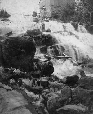
The second image, a postcard photograph of Mason Falls dating from the late 19th century, shows the site of a mill. This time, the mill appears much closer to the river and in the larger part of Mason Falls. It seems likely that this photograph was taken after the 1896 fire, once the mills had been rebuilt at a slightly different site.
GEOGRAPHICAL COORDINATES
Lots 18 and 19 — Range 5
46.0543⁰ N 73.6859⁰W
These approximate coordinates need to be validated by field surveys.
|
|
Site no. 4 — Lot 22 — Range 7 — Hobbs / Bagnall / Munroe mills
While the Dugas mills were the first to be built on the territory of Rawdon township, the second group of mills was built by George Hobbs around 1830.
These mills were located between chemin du Lac-Morgan and chemin de Saint-Alphonse (Route 337).
In a text entitled “George Hobbs, a Rawdon Loyalist” (Up to Rawdon – pages 337-345), Daniel Parkinson explains that, to his knowledge, George Hobbs was the only United Empire Loyalist to settle permanently in Rawdon. Born in New York State and married in 1797 in Prince Edward Island to Martha Crosby, an Irish woman, he reportedly arrived in Montréal between 1798 and 1800. A baker, George first settled with his family in Faubourg à m’lasse, then moved to Sault-au-Récollet in 1806. They applied for lands in Rawdon in 1820 and were granted them on January 15, 1821, by Order in Council. George Sr. and his son obtained letters patent for lot 22 of Range 7 in January and March 1834. The mills, built before 1831, were listed in the 1831 census (a sawmill and an oil mill).
.
Over the years, Robert Bagnall developed a large agricultural business and acquired several hundred additional acres. A lumber merchant and militia major, Mr. Bagnall was an influential figure in the community. In fact, a section of Daniel Parkinson’s book Up to Rawdon focuses on Robert Bagnall and his family. Mr. Parkinson mentioned having found documentation in the minutes of the meetings of the Anglican Church’s administrators and vestry members corroborating the information that Mr. Robert Bagnall also operated a sawmill.
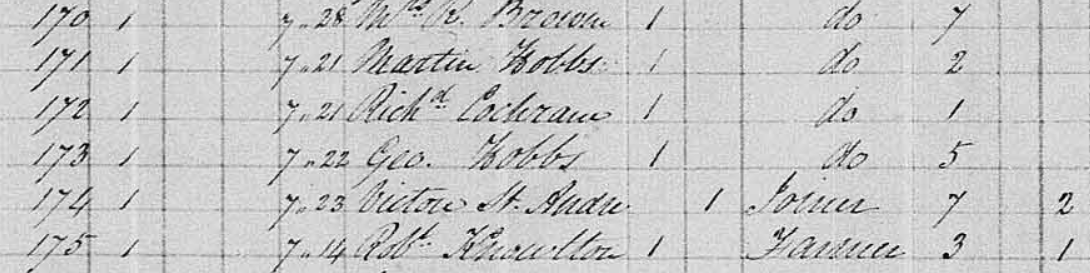
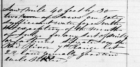
The Bagnalls sold this mill on April 17, 1865, to George Munroe, as specified in deed of sale no. 1037 in the office of Notary John Horan. The 1851 census confirmed the presence of this sawmill on lot 22 of Range 7, but it was associated with George Munroe, who identified himself as a “millrite” [sic] or maintenance mechanic. Born in Scotland and aged 45 at the time of the census, Mr. Munroe was to operate the mill for the Bagnall family. The mill was described as measuring 40 feet by 30 feet, with two sets of saws. As noted by the census taker, this site had sufficient hydraulic power for all types of mills or factories, except in the month of July.
GEOGRAPHICAL COORDINATES
Lot 22 — Range 7
73.7038⁰W 46.0758⁰N
These approximate coordinates need to be validated by field surveys.
The information available confirms that Messrs. Hobbs (~1825-1841), Bagnall (1841-1865) and Munroe (1865-????) all owned the mill located on part of lot 22 of Range 7 at different periods.
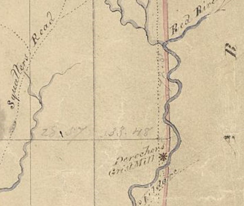
Site no. 5 — Lot 28 — Range 10 -- Desrochers/Cornellier/Mason Mill
The Desrochers grist mill was identified on the map drawn by James Dignan in 1844, following the survey of Ranges 9_, 10_ and 11_ of Rawdon township. This mill was located on lot 28 of Range 10 (see map below) of Rawdon township, at the very beginning of the Rouge River on the territory of Rawdon (after crossing the line dividing the townships of Rawdon and Kildare / municipality of Saint-Alphonse-de-Rodriguez)
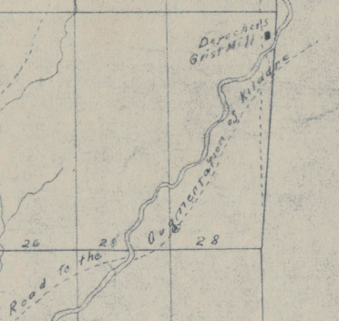
The Holtby map also identified lot 28 of Range 10 in the name of “Deroche” [sic].
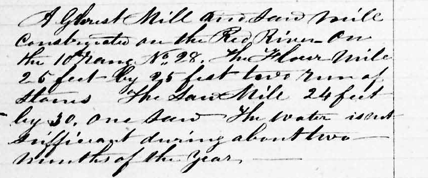
Born in Saint-Jacques, Louis-André Brien, known as Desrochers, owned a sawmill in addition to the flour mill. As reported in the 1851 census, the flour mill measured 25 feet by 25 feet and had two millstones. The sawmill had only one saw. However, these same census records specified that there was not enough water to operate the mills for a period of about two months a year.
The census records identified Louis Brien Desrochers and his son, also called Louis Brien, as well as Joseph Allard as millers. They were aged 59, 29 and 38 years old, respectively, at the time of the census.
According to Marcel Fournier, Mr. Brien, known as Desrochers, settled on Range 2 of Rawdon township around 1850. Mr. Brien Desrochers was elected mayor, the first in the history of Rawdon township, on December 17, 1855.
GEOGRAPHICAL COORDINATES
Lot 28 — Range 10
46.1358⁰ N 73.7084⁰W
These approximate coordinates need to be validated by field surveys.
Unexplainedly, these mills and the land were bought back by Louis-André Brien dit Desrochers, in a sheriff’s sale on June 15, 1861. A few months later, on March 5, 1862, they were resold to Narcisse Cornellier, a farmer from Saint-Ambroise who, in turn, resold them to Edward Mason, a machinist-millwright from Chertsey. The deeds of sale (16, 17) described the property located in Range 10 of Rawdon township (the lot is not specified) as follows: approximately 13 arpents (about 760 metres) deep by 1 arpent (about 60 metres) at the front and 3 arpents (about 180 metres) at the centre, bordered at the front by James Boyce, at the rear by the widow O’Colgan, on one side by John Shields and on the other side by Samuel Coltren. This site included two houses, two mills and a stable and had water power and privilege running through the property. The site was sold for $1,200. To ensure payment, George Copping intervened in the contract and accepted responsibility, jointly and severally, with Edward Mason, by mortgaging lot 20 of Range 4.
- Avis technique sur le Lac Rawdon/Pierre Bertrand Consultant, octobre 2023 (Technical opinion of Rawdon Lake, Pierre Bertrand Consultant, October 2023)
- Plan directeur de protection du bassin-versant du Lac Rawdon — Rapport final/CIMA+, décembre 2013 (Master plan for the protection of the Rawdon Lake watershed, final report, CIMA+, December 2013)
- Bilan de phosphore et prédiction de l’eutrophisation du lac Rawdon/Groupe Hémisphère, juillet 2015 (Phosphorous report and eutrophication prediction for Rawdon Lake, Groupe Hémisphère, July 2015)
- Opening Rawdon Township: Early locations by Loyalists and the First Settlers, Daniel B. Parkinson
- Act # 386 – February 23, 1817, Notary Thomas Bédard, notarial archives, National Library and Archives of Quebec)
- Act # 1048 – June 21, 1817, Notary Pierre Mercier, notarial archives, National Library and Archives of Quebec)
- Act # 462 – March 9, 1818, Notary Thomas Bédard, notarial archives, National Library and Archives of Quebec)
- List of land grants, Rawdon Township, Registry of the Surveyor General of Quebec
- Censuses of 1825, 1831, 1851, 1861 and 1871, https://www.bac-lac.gc.ca
- La Minerve newspaper, issue dated January 11, 1830, National Library and Archives of Quebec)
- Acts dated April 22, 1828, Notary Antoine Minier dit Lagacé, notarial archives, National Library and Archives of Quebec
- Up To Rawdon: Settlers at Rawdon Township, Lower Canada c. 1820-1852. Their Origins and Continued Migration Across Canada and the United States 2 vols. [S.l.]: Daniel B. Parkinson, 2013
- Act # 447 – July 21, 1865 — Notary S.-Ulric Brien dit Desrochers, notarial archives, National Library and Archives of Quebec
- Sous le clocher de Saint-Liguori/Jean Gagnon, 1979 (Under the bell tower of Saint-Liguori)
- Commission de toponymie https://toponymie.gouv.qc.ca/ct/ToposWeb/Fiche.aspx?no_seq=63997
- Act # 4156 – March 5, 1862 — Notary Jules Bourgeois, notarial archives, National Library and Archives of Quebec)
- Act # 1018 – July 18, 1864 — Notary John Horan, notarial archives, National Library and Archives of Quebec)