This article presents and interprets different plans and maps of the township, village and, today, the municipality of Rawdon since the first known plans and maps drawn from the late 18th century to the most recent maps produced with digital tools.
Plan included with the land petition from Captain Grant and Captain Dunbar, by the surveyor William Rankins (1789)
In his book entitled " Rawdon : 175 ans d’histoire ", (Rawdon: 175 Years of History), Marcel Fournier reproduced, on page 29, a plan with the following title: Plan of the river Lac Ouareau for the captains Grant and Dunbar ». This map was reportedly filed in the fall of 1789 and may be consulted in the Registre des demandes de terre 1789-1830 (Register of land petitions 1789-1830) available at the Archives nationales du Québec (Quebec national archives).
Plan included with the land petition from Captain Bt. Roorback, by the surveyor William Fortune (1793)
Still in Marcel Fournier’s book, he refers to a plan drawn by the surveyor William Fortune dated January 7, 1793, and filed on May 3, 1793. This plan was included with a land petition submitted by Captain Bt. Roorback. This petition is mentioned on page 308 of appendix II in the book entitled " La colonisation de la province de Québec 1791-1815" by Ivanhoë Caron. Just like for the plan drawn by the surveyor Rankin, it was not possible to get a digitized copy.
Diagram of the township of Rawdon by Samuel Holland (around 1795)
This diagram of ranges 1 and 2 of the township of Rawdon, drawn around 1795, even before the township was officially recognized, identifies the lots reserved for the Crown and the Clergy as well as the people who were granted the lots. A preamble to this diagram indicates the instructions provided to the surveyor.
Daniel Parkinson transcribed the text preceding this diagram of the township of Rawdon. The text informs us that, according to His Majesty’s instructions, every township must be subdivided into lots of 200 acres before any grant of land can be made. The instructions provided to the surveyor describe the work to be performed.
Source: BAnQ: E21,S555,SS1,SSS1,PR.5A
Instructions for the surveyor (transcribed by Daniel Parkinson)
In due obedience to His Majesty’s Instructions, every Township ought to be subdivided into lots of Two hundred acres, according to the Diagram D or E, before any grant can be made therein, in order to ascertain the true scites [sic] of the reservations for the maintenance of a Protestant Clergy, and the reservations for the future disposition of the Crown.
This Tract, as may be seen by the Surveyor General’s note at the foot of this Plan, has not been subdivided; and yet, a Patent has passed for lots therein to several grantees.
The reservations can never be found but by actual admeasurement, marking the corners by Posts of durable wood, six inches square at least; and by blazing or marking the trees nearest to the corners, with letters deeply cut with a K for the Crown lots and with a C for the Church lots.
This is one of the Original conditions to be perform’d by the Applicants for lands in any Township, prior to the passing of any Patent for any portion of the land in that Township.
It might be expedient to lay down a rule, that no further grant shall be made of land in any Township set apart for those who may have obtained orders for specific quantities (1), until a return of the admeasurement of the outlines at least, actually run & made in the field, shall have been regu … y … the Surveyor General’s Office by a Surveyor duly admitted & sworn; in which return shall be inserted, a plain and clear description of the manner in which the four corners of the Township have been marked, and likewise every other angle occurring in running the outlines, whether by strong Posts of durable wood, or by Posts surrounded by stones, or otherwise permanent marks readily to be found, and easily ascertained.
In the case of the Outlines of a Township having been accurately run, and the depth of every range of Lots exactly marked by posts, and numbered in the field, the subdivision might in such case be made in the drawing room in the Surveyor’s Office. If the front line of Rawdon has been really run, together with the side lines and the back boundary line, measuring each Eight hundred Chains, the subdivision may be accurately made in the closet [sic[2]];
If the front line of Rawdon has been really run, together with the side lines and the back boundary line, measuring each Eight hundred Chains, the subdivision may be accurately made in the closet [sic(2)]; but should an offer be made for a Lease of the Church lots; or if Government should incline to sell the whole of the lots reserved for the Crown in Rawdon, their scite [sic] could not be ascertained without an actual survey, and subdivision & marking the corners of the lots intended for sale.
Designations by Samuel Holland
on the second range
14 K / Crown
10 C / Church
12, 12 (west half) and 13 / George McBeath (3)
on the first range
16, 23 K / Crown
12, 19, 26 C / Church
17, 18, 20 west half of 21 / Ephraim Sandford
East half of 21, 22, 24 James Sawyer [sic]
25 Margaret Tucker
Below the first range is the Seigniory of St. Ours or Lachenaie, and from lot seven eastwards, it is Seigniory of St. Sulpice. Kilkenny is to the west, Kildare to the east and Wexford to the north.
Scale: 40 chains to one inch.
No part of this Township of Rawdon has ever been subdivided into farm lots.
[Signed] Samuel Holland, surveyor
(1) Concerning “… apart for those who may have obtained orders for specific quantities,” Daniel Parkinson writes that that he believes this refers to negotiations by Captain Ralph Henry Bruyeres, of His Majesty’s Corps of Engineers, and Dr. George Selby, the heirs of Captain William Dunbar who had been granted 3,000 acres in 1789. It was confirmed, in detail, in 1805 after Holland’s 1795 survey and included what would become Rawdon’s first range, lots 1, 3, 4, 6, 7, 8, 10 & 11, and second range, lots 2, 4, 5, 6, 8, 9 (later the Parish of Sainte-Julienne). George McBeath asked for 3,000 acres and was granted the 500 marked on this map.
(2) Daniel Parkinson uses the term sic in brackets, after a word, showing that it is quoted exactly as in the original text, indicating some spelling or typographical particularity.
(3) To find out more about McBeath, see footnote 2 on page 337 in the updates to Daniel Parkinson’s book on Daniel’s UP TO RAWDON website. The other loyalists mentioned can be found in the UP TO RAWDON book on pages 1046, 1062, 1075, 1081 and in the updates to these pages.
Diagramme du Canton de Rawdon (1804)
Retrouvée sur le site web du « Greffe de l’Arpenteur-Général du Québec », cette carte intitulée « Diagram of the Township of Rawdon » constituerait probablement la première carte complète du Canton de Rawdon à une échelle de 80 chaînes au pouce. Selon le Greffe de l’Arpenteur-Général du Québec, elle aurait été produite en mars 1804. Les annotations manuscrites ont probablement été ajoutées par la suite afin d’identifier les propriétaires des lots. Une version légèrement différente de cette carte, signée par Joseph Bouchette, est reproduite par Daniel Parkinson dans son livre « Up to Rawdon »
Une note explicative précise que le Canton a été subdivisé en 11 rangs à équidistance de 72 chaînes 72 chainons numérotés du sud-est au nord-ouest de 1 à 11 inclusivement. Ces rangs ont été subdivisés en 28 lots de 28 chaines 57 chainons de large par 72 chaînes 72 chainons de profond numérotés du sud-ouest vers le nord-est de 1 à 28 inclusivement.
Comme ces chaînes et chainons ne sont pas tout à fait évidents, voici quelques informations qui aideront à comprendre. La chaîne mesure 66 pieds et est divisée en 100 chainons….ce qui fait que chaque rang est situé à une distance de 4800 pieds l’un de l’autre. Comme il y a 11 rangs, le canton mesure donc 52 800 pieds soit exactement 10 milles. Les 28 lots mesurent 28 chaînes 57 chainons de large ce qui permet de calculer la largeur d’un rang à ce même 52 800 pieds ou 10 milles. En multipliant la largeur du lot par sa profondeur, chaque lot contient environ 200 acres (mesure encore utilisée pour les superficies de grandes étendues de terre). En termes plus modernes, le Canton de Rawdon mesure donc 17,6 kilomètres par 17,6 kilomètres tandis qu’un lot cadastral contiendra environ 80 hectares.
Map of the Township of Rawdon, by Joseph Bouchette, jr. (in 1821)
This map drawn to a scale of 40 chains to one inch is the first complete map of the township of Rawdon. A chain is an Imperial system unit of measure that can be equal to either 66 or 100 feet, depending on the period. The English township was subdivided into 11 ranges of 28 lots. Each of these lots had an area of 200 acres. The township measured 10 miles by 10 miles.
This map from 1821 identifies the roads, rivers and certain lakes on the territory as well as the location where Philémon Dugas settled.
Map of the 9th, 10th and 11th ranges of the township of Rawdon, by the surveyor James Dignan – 1844
This map was drawn to a scale of 40 chains to one inch following the surveying of the ninth, tenth and eleventh ranges of the township of Rawdon by James Dignan in September, October and November 1844. This map identifies roads, including those leading to Wexford and to the augmentation of Kildare, the Dorwin and squatters’ forestry chantier roads, a few lakes and the Desrochers grist mill. An annotation on the west side of the 9_ range mentions “old line,” which would justify this new surveying of the last lots of the township.
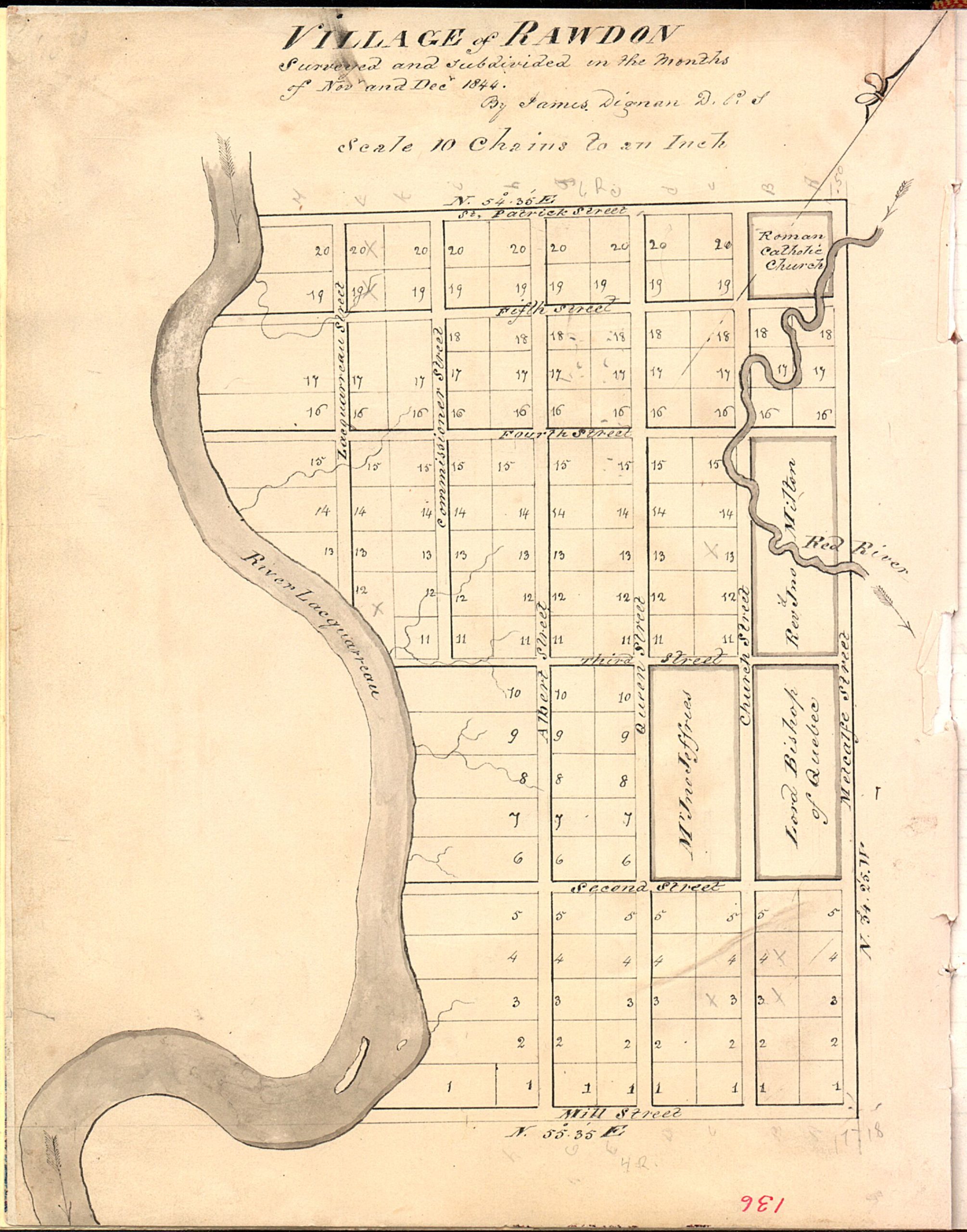
Plan of the village of Rawdon, by James Dignan – November-December 1844
The first in a series of three, this plan of the village of Rawdon was drawn by the surveyor James Dignan following a survey performed in November and December 1844. An article by Daniel Parkinson tells us more about this surveyor and his family, originally from Ireland. Drawn to a scale of 10 chains to an inch, this map locates the Lacquarreau (Ouareau) River and the Red (Rouge) River. It also provides the geographic coordinates delimiting the territory of the village that was starting to take shape. Probably for land planning purposes, this plan subdivides part of the original lot (lot 17, range 5) into smaller-sized parcels and draws streets from Mill Street (now 1st Avenue) to St. Patrick Street (now 6th Avenue) and between the two rivers, namely, the Ouareau River and the Rouge River.
Source: https://numerique.banq.qc.ca/patrimoine/details/52327/3142798 E21,S555,SS1,SSS4,PR.11
This 1844 survey was performed by
James Dignan, D.P.S., an Irish-born surveyor whose name
appears on the 1851 and 1871 censuses in Berthier. He died in
Berthierville on March 28, 1872, at the age of 73. Fournier incorrectly names him Dignam and, in material found in BAnQ, he is named Dingman, a
a cataloguing or clerical error. His nephew, Frederick Patrick Dignan, born in
County Meath, became a priest in Saint-Hyacinthe in 1868 and was a witness at
at his uncle’s burial. The Reverend Dignan had been brought to Canada by
his uncle and is buried in Saint-Philippe-de-Windsor-Mills, his parish church. His 1895 burial registration gives the family history (source: Drouin index).
James Dignan’s work is
is well represented in BAnQ. He surveyed the 9th, 10th and 11th ranges of the township of
Rawdon en 1844, localisant les lacs et les » chemins de squatters » qui existaient avant que les colons ne soient obligés de défricher des routes.
Dignan (aka Dingman) completed many survey maps, and one can find Cathcart, Chertsey
Daillebout [sic] and Ramsay, Saint-Gabriel-de-Brandon and others as early as 1832 in the archives.
In the row of lots where the Red River crosses the edge of the village, one
porte la mention » Rev’d Jno. Milton « . John L. Milton était le titulaire anglican en 1834 – 1836. Il semble que ce terrain lui ait été octroyé personnellement. (En 1844 et 1845, lorsque les cartes ont été dessinées,
Rowland Bourne was the minister, who succeeded C. P. Reid in 1836-1837.) In the row below, there is a block of ten lots in the name of John Jefferies, a prominent early land owner and businessman (read UP TO RAWDON, Part One, about him and his second wife: John Jefferies, Butcher and Nancy Bridge). East of that is a block of ten lots in the name of the Lord Bishop of Quebec reserved for the Anglican church and cemetery, replacing those of the Forks. (See Christ Church Early Days, in UP TO RAWDON, Part Two.)
Source: https://numerique.banq.qc.ca/patrimoine/details/52327/3142798
E21,S555,SS1,SSS4,PR.11
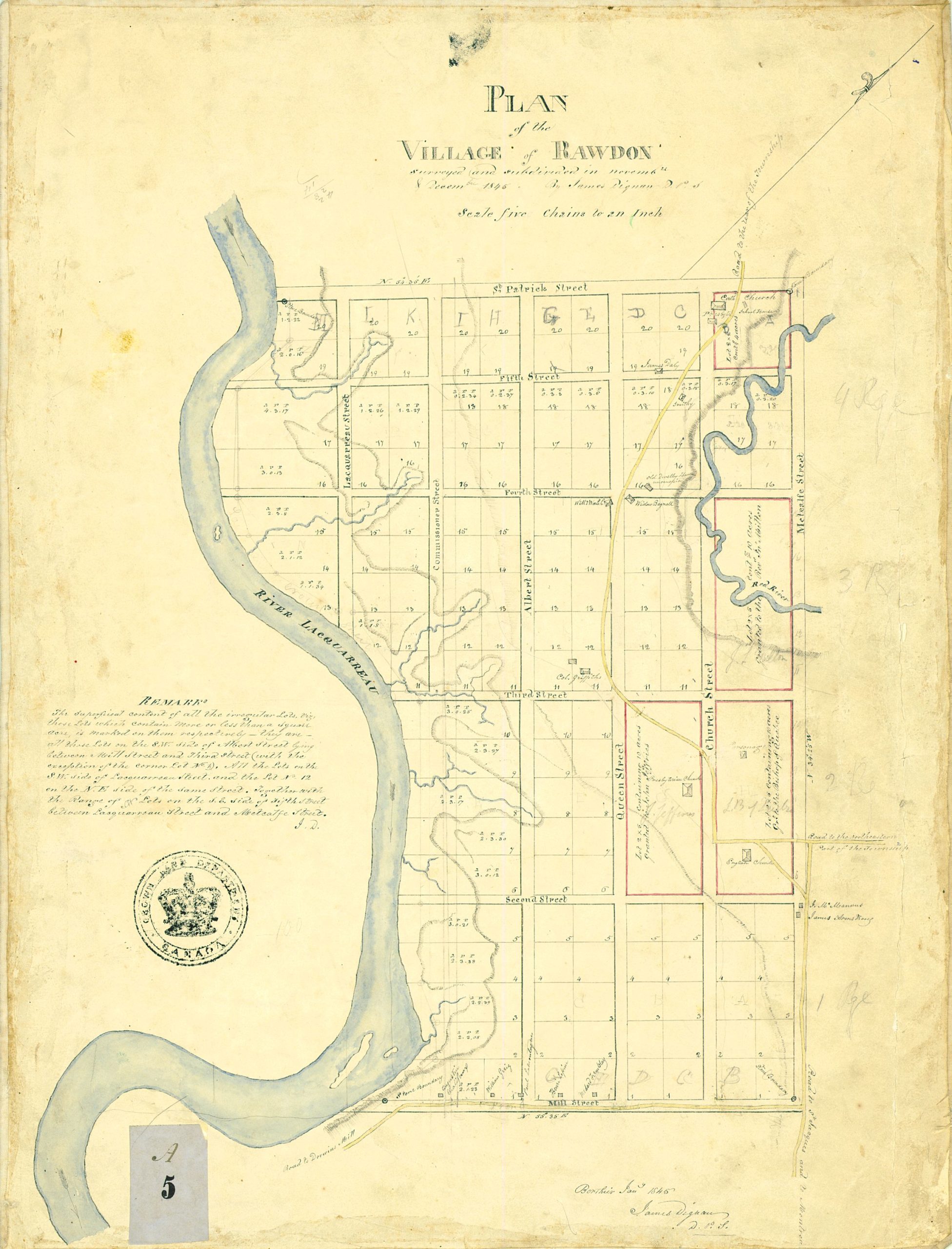
Plan of the village of Rawdon, by James Dignan – January 1845
This second plan of the village of Rawdon, dated January 1845, was prepared in Berthier by the surveyor James Dignan, and it bears his signature. Drawn to a scale of 5 chains to an inch, this plan complements the one prepared in late 1844 with the addition of some colours. A remark included on this second plan concerning the “irregular” lots suggests that the “regular” (square) lots had an area of one square acre, or about 208 feet by 208 feet. As a historical reminder, an acre measured one chain (66 feet) by one furlong (660 feet), that is, 43,560 square feet. This second plan adds several items of information to the previous version, including the areas of the “irregular” lots, the roads that went through the territory, the locations of the boundaries and the owners of certain lots. The areas of the irregular lots are given in “acres, roods, perches” under the abbreviation a. r. p., with 4 roods per acre and 40 perches per rood. Even if the municipality of Rawdon now has a slightly different shape, there is reason to believe that James Dignan’s work largely influenced the current configuration.
This colour map of the village was signed by James Dignan D.P.S. [sic – not Dignam or Dingman] on January 9, 1845, with annotations indicating elevation, creeks and rivers.
A note on this plan indicates that it was surveyed and subdivided in November and December 1845. It is clear, however, that certain additions were made at a later date (see note 1).
Les intervalles alphabétiques sont plus clairs mais la lettre « F » a été omise. Une échelle de 5 chaînes au pouce a été utilisée.
At lots 19 and 20 of columns A and B are
the Catholic Church, the presbytery (presbytère in French in the English text)
the English text) and the school house, on a lot of 2 acres by 2 acres, or 4 acres.
Lots 19 and 20 of columns C and D are the property of James Daly.
A smithy (the blacksmith is not identified) is located along the road on lot C-18.
Sur le lot D-16 – L’annotation en langue anglaise « old dwelling house, unoccupied » indique qu’une vieille
unoccupied house is set back from the road.
Across Fourth
rue, le nom de « Willm Walsh » apparait au lot E-15. Un certain William
Walsh buried in Christ Church Cemetery, but
he was living in Sainte-Julienne in 1861. Daniel Parkinson specifies that this
is the William Welsh [sic] from Lismore, County Waterford, who married Jane Daly in 1840 at St. Patrick’s Church.
Nearby on lot D-15 is Widow Bagnall. Harriet Pigott was the widow of the merchant Robert Bagnall, formerly of Tullamore, King’s County; see Bagnall, Blagrave & Pigott: Family Connections in the book UP TO RAWDON. Part One. Mrs. Bagnall also held lot D-14.
The 10 acres on either side of the Red River are still marked for the Reverend Jno. Milton.
Colonel Griffiths [sic] had
a house located on lot E-11. He had five lots from E-10 to E-14,
as mentioned on page 315 of the chapter referenced in an earlier section.
Les 10 acres du bloc « Y » (tel qu’identifié par la lettre Y dans le « Map of the village of Rawdon by the Surveyor General’s Office – April 1845”) are
identified au nom de l’évêque de Montréal et la partie est de ce bloc est annotée « English Church ».
Le bloc « Z » de 10 acres est identifié au nom de John Jefferies avec comme seul bâtiment l’église presbytérienne dont il est question à la section portant sur le « Plan of the village of Rawdon by the Surveyor General’s Office – April 1845.”.
La rue « Mill Street – en anglais sur le plan ou rue du Moulin » est située au bas de la carte avec les lots portant le numéro 1 ; il y a une « borne en pierre » annotée à chaque extrémité. Nous avons consulté l’arpenteur Paul Melançon qui nous a indiqué qu’il s’agissait de bornes placées par M. Dignan aux quatre coins du territoire arpenté. La rue Mill suit ensuite la rivière Lacqurreau [sic] jusqu’au moulin Dorwin « Dorwin’s Mill sur le plan ».
Le lot numéro E-1 est identifié « Medard Tremblay ». Il y avait une famille avec ce nom de famille au lot 10 du quatrième rang qui avait été accordé à un Joseph Tremblay en 1836. Rasy (Rostine ?) Trambles [sic] un menuisier était locataire à cette adresse en 1831. Médard Tremblay a fait baptiser une fille à l’église St-Patrick en 1843. Les événements enregistrés à St-Jacques pour Joseph et Médard Tremblay pourraient l’avoir été pour ces familles.
Henri Lépine is identified on lot G-1. The names Lépine and Lapine are indicated on the old map of the township of Rawdon, each with 50 acres on the second range. Charles Lépine was a carpenter in the village (1852 Census).
William Grigg is identified on lot H-1. He may be a relative of Reuben Grigg who signed settlers’ petition in 1828 and who is named in the 1831 Census, or perhaps William is related to Isaac Grigg from Somerset, England, who was a blacksmith and who moved with relatives, in late 1851, to Huron County, Ontario, where a William Grigg was a blacksmith in Clinton, Huron County. Many references to the Griggs are found in the book UP TO RAWDON.
On lot I-1, Augustin Chalifoux was a journeyman, and he had a son baptized at St. Patrick’s Church in 1844. Xavier
Tremblay was the godfather. Joseph Chalifoux is identified on lot S21 of the third range in the 1861 Census of Rawdon. These men were related and have descendants in Rawdon today.
Source: https://numerique.banq.qc.ca/patrimoine/details/52327/3142589
E21,S555,SS1,SSS23,PR.1
From research not included in the book UP TO RAWDON: between April 1846 and June 1848, village lots were purchased by James Armstrong*, James Daly, Hugh Daly, Jedediah H. Dorwin, Patrick Carroll, John Kite, James Cunningham, Harriet Bagnall, Daniel McGarry, William Walsh, Isaac Grigg and Thomas Griffith. (Appendix DDD to an address to the Legislative Assembly, Crown Land Department, Montréal, February 28, 1849).
* Information about names not on the village map: James Armstrong was a tavern keeper on lot 21 S of the third range in 1831. He was a Protestant and is only partly identified in the book UP TO RAWDON. Hugh Daly may be the man identified in the 1824 Statistical Survey and perhaps the man who died at 85 in 1875 and one of the members of the large Daly family in Rawdon. The story J. H. Dorwin: He Tried to Put Rawdon on the Map is found in the book UP TO RAWDON, Part One. Patrick Carroll was a son of original settler John Carroll on lot 17 of the seventh range. John Kite was one of the earliest settlers, c. 1819; see “Kite of Wiltshire and Rawdon” in the book UP TO RAWDON, Part One. James Cunningham and his wife Mary Topping were Irish Protestants whose descendants are mentioned in the book UP TO RAWDON. Daniel McGarry was Irish, a cordwainer (shoemaker) identified in the 1852 Census of Rawdon, who had children baptized in the 1850s at Christ Church.
In addition, the Grants Book shows lots granted to J. C. Milton and the Anglican Church in 1839 and 1840, John Jeffries in 1845, Bernard McManus in 1846, the Municipality of Leinster and the Municipality of Rawdon in 1849 and 1852, James Cunningham, Patrick Carroll, Jedediah H. Dorwin, James Daly and William Norrish*. It is not clear if the duplicate names are for the same or additional lots.
* The story “William Norrish: Survivor” in the book UP TO RAWDON presents him as a man of determination.
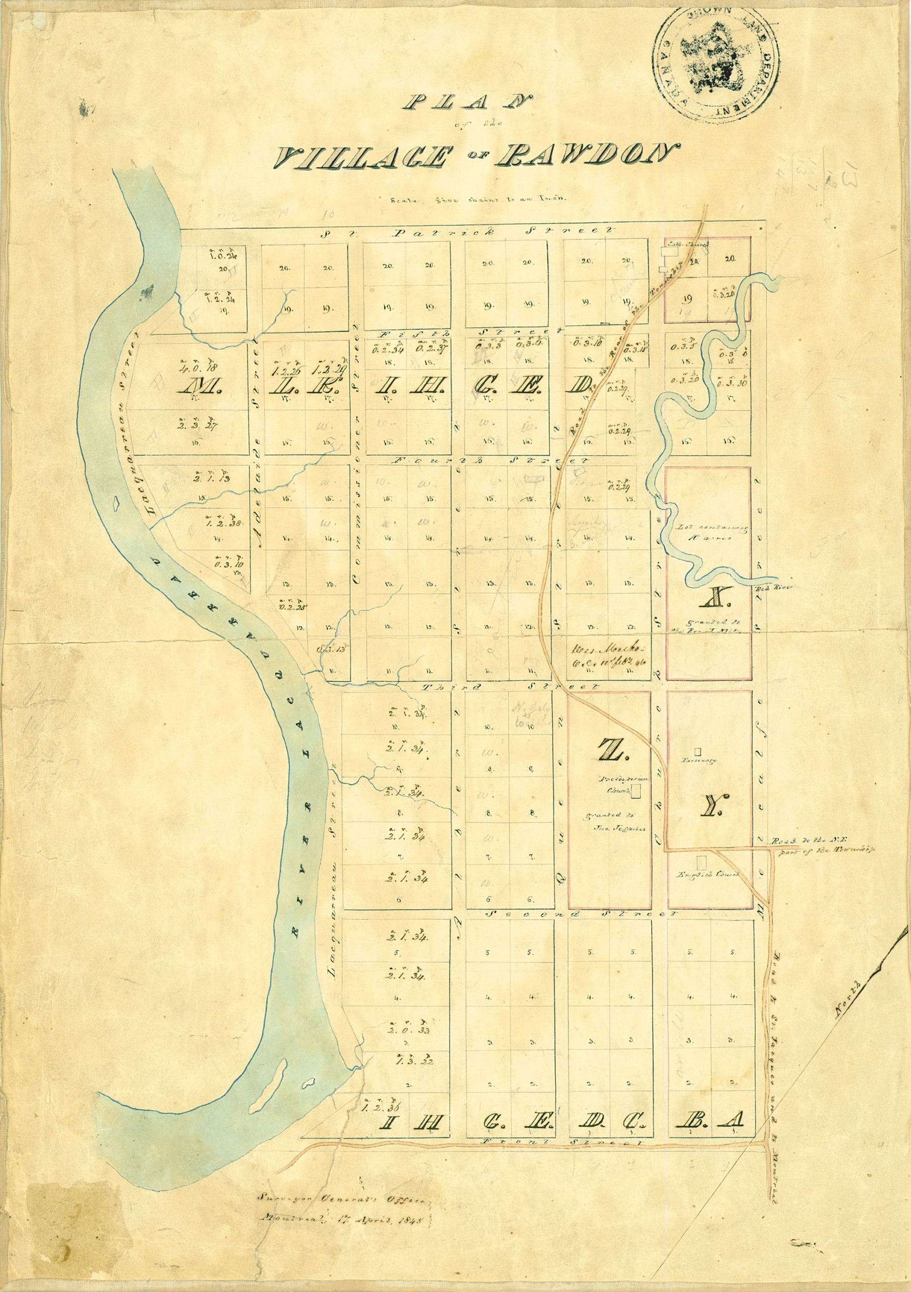
Plan of the village of Rawdon by the Surveyor General’s Office – April 1845
TThis third plan of the village of Rawdon, dated April 17, 1845, was drawn by the Surveyor General’s Office in Montréal. It is a cleaned-up version, still to a scale of 5 chains to an inch, of the map prepared in January of the same year by James Dignan. There is reason to believe that this plan bearing the seal of the Crown Land Department would become the official version for the constitution of the village of Rawdon. A few changes can be noted in relation to the January version prepared by Dignan. The configuration of Commissioner Street and Lacquarreau Street is changed on this later plan, as Lacquarreau Street is moved and a new street named Adelaide is added. Also, Mill Street is now identified as Front Street on this plan.
Actually, in Rawdon, the streets have become avenues. Commissioner Street (rue des Commissaires) would run only between 5th and 6th Avenue, while Adelaide Street would go only from 5th Avenue halfway to 4th Avenue. As well, 2nd + 3_ Avenues would never get to the Ouareau River from Metcalfe Street. Lastly, it seems likely that the avenues are not located exactly where determined by the surveyor Dignan.
This diagram is credited to the Surveyor General’s Office in Montréal and is dated April 17, 1845. It is clearly a copy of the 1844 map (previously identified), but the scale is 5 chains to an inch and letters were added for the rows of lots from east to west, starting with A in the northeast corner and going up to M in the northwest corner; they are mostly, but not always, in alphabetical order. The rivers are in blue.
Dans le coin nord-ouest se trouve le « chemin vers l’arrière du canton », prolongement du chemin de « Saint-Jacques et Montréal ». Il traverse les lots A-20 et B-20, qui sont annotés « Église catholique », avec deux icônes représentant des bâtiments. Le grand lot « X » en dessous est coupé en deux par la rivière Rouge et est nommé « lot contigu accordé au Révérend Milton ». En dessous se trouvent deux lots 11 identifiés « Wes Meth.(partie illisible) … feb’y 46 » accordés à la suite de la pétition d’un groupe de citoyens pour la construction d’une chapelle méthodiste. (voir livre UP TO RAWDON Part One). La page 315 mentionne qu’ils ont obtenu les lots C-11 et D-11, anciennement détenus par le colonel Griffith. La page 648 nomme les membres du comité.
In columnss C et D en-dessous se trouve le grand bloc « Z » accordé à John Jefferies avec une icône indiquant l’emplacement de l’église presbytérienne. J’ai déjà rédigé des notes concernant sur ce bâtiment qui pourrait être à l’origine l’église construite par Burton sur sa propriété située sur le lot 16 du premier rang. Ce bâtiment fut ensuite utilisée comme salle d’entrainement par la milice en 1836 – 1837. Il était certainement en place avant que le plan de village ne soit formalisé. Read: “An Irony of Rawdon History: Did Burton’s Church Become Presbyterian?” The village existed before the plan was prepared.
Les mot » parsonage » et « English Church sont inscrits dans le bloc » Y » et identifient un presbytère et l’église anglaise connue officiellement comme l’Église d’Angleterre et d’Irlande. Le bâtiment fait face à la route qui mène à la partie nord-est du canton.
Source: https://numerique.banq.qc.ca/patrimoine/details/52327/3142590 E21,S555,SS1,SSS23,PR.1A
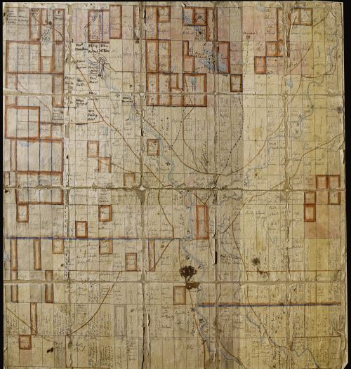
Holtby Map
This map of the township of Rawdon was used by William Holtby Jr., Secretary-Treasurer of the Township of Rawdon, to record the owners of lots around 1845. This map has travelled extensively. Holtby’s descendants first settled in Waverly, Minnesota, and later in Los Angeles, Seattle and Denver. The map was finally brought back through Daniel Parkinson, a descendant of William Holtby Jr. living in Toronto, and returned to the Municipality of Rawdon in 2022.
Greffe de l'Arpenteur général du Québec
The Greffe de l’arpenteur général du Québec is a public register used to record, maintain and disseminate all documents prepared under the authority of the Surveyor General of Quebec. These documents serve to represent the parcelling of the lands in the domain of the State and to reestablish the limits of surveys in the townships, among other things.
An interactive map available at: https://appli.foncier.gouv.qc.ca/gagq (in French only) allows users to find the different territorial subdivisions, including primitive surveys and the cadastre of Quebec.
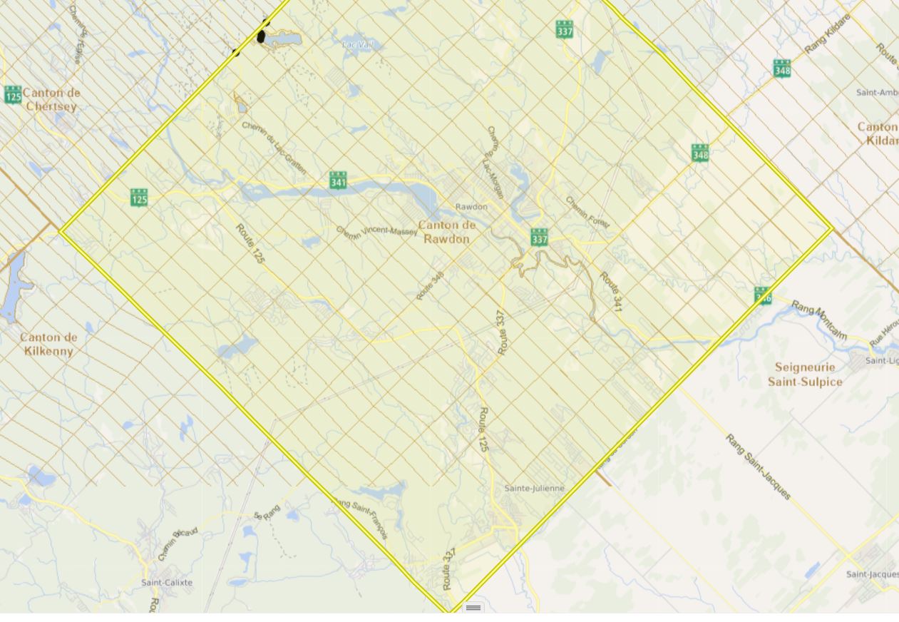
Historical map of Lanaudière
The designer of the Chroniques anachroniques website (https://montrealbb.ca/) developed an interactive historical map of Chertsey in 2018 that now extends to the Lanaudière region: https://montrealbb.ca/carte-historique-lanaudiere/ (in French only). This map has many layers. For the territory of the municipality of Rawdon, it lists, among other things, the owners of the original lots as they appeared in Daniel Parkinson’s transcription of the Holtby map.
This interactive map uses" open-source software for sharing geographical data, called Open Street Map. As indicated on the Chroniques anachroniques website, it is easier to access the different controls of the map on the website OpenStreetMap : http://u.osmfr.org/m/643883/.
Maps available on the Municipality of Rawdon website
The Municipality of Rawdon provides its residents and visitors access to several maps, including an interactive map (in French only): https://rawdon.ca/fr/carte-interactive
This interactive map identifies the locations of the following features on its territory:
- Tourist attractions
- Electoral districts
- Parks and green spaces
- Residential projects
- Collection sectors
- Municipal services
The Municipality’s website also allows users to consult the master plan and the zoning plans as well as the water constraints plan and the plan of zones exposed to landslides: https://rawdon.ca/fr/municipalite/administration/plan-durbanisme (in French only).