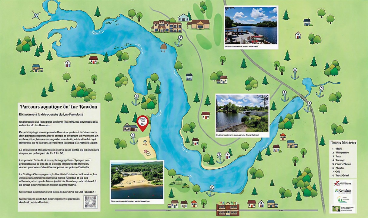
Self-guided Rawdon Lake Aquatic Tour with its eight points of interest.
Welcome to Rawdon Lake !
Designed as an educational, eco-friendly and accessible activity, this self-guided tour can be enjoyed by boat in the summer and on foot in the winter. It showcases Rawdon’s natural and cultural heritage in a peaceful and welcoming setting.
An accessible tour
The route forms a loop around most of Rawdon Lake. In summer, it begins and ends at the boat launch located across from the “À la dérive” business (see the “Vous êtes ici” marker on the map). In winter, it begins and ends at the entrance to the ice rink on the lake.
The points of interest can be discovered by visiting this website.
The tour begins at the municipal beach, the first point of interest (point 1).
Practical information
The loop covers 4.1 km and typically takes 1 to 1.5 hours to complete. However, it can be done in several stages, depending on the visitors’ pace and interests. The points of interest are presented on the website. There are no signs identifying the points of interest on site.
Approximate distances between points of interest:
From the beach (point 1) to the resort area point of interest (point 2) = 537 metres
From the resort area point of interest (point 2) to the four points around the dam bridge (points 3-4-5-6): 1,033 metres (1 kilometre)
From the dam bridge (points 3-4-5-6) to the golf course pier (point 7): 1,681 metres or 1.7 kilometres
From the golf course pier (point 7) to Nichol Park (point 8), then back to the starting point: 867 metres
Exploring the points of interest
The QR code shown on the illustrated map of the lake located at the beach (see the "Vous êtes içi" (You are here) sign) provides access to a description, history and photographs of the following points of interest:
Rawdon Lake begins at the small bridge on Lakeshore Drive, near Lucien-Godin Street, and ends at the dam bridge on 3rdth Avenue. The water flows from this first bridge toward the dam bridge.
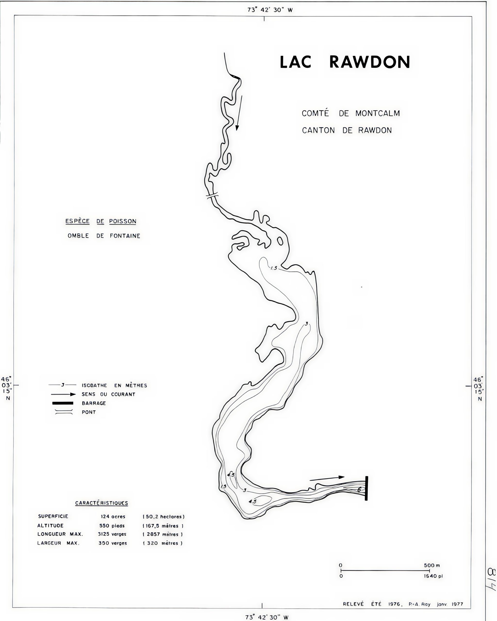
Table 1: Marine Data Sheet —Rawdon Lake, Montcalm County, Rawdon Township, Official Marine Data Sheet 0814
The lake, which is 2.8 kilometres long, stretches on both sides of the Rouge River. At its widest point, it measures nearly 320 metres.
According to this bathymetric map dating from 1978 (1), the lake covers a total area of 50.2 hectares (124 acres) and is located at an elevation of 157.5 metres (550 feet above mean sea level).
The depth ranges from less than 1 metre upstream to nearly 4.5 metres downstream. Upstream from the beach, it is less than 3 metres deep. (2)
The lake was stocked with trout for four decades, until 2020. In the deepest parts of the lake, there are still a few trout that reach it via the Rouge River from Saint-Alphonse. Yellow perch, bass and pike are also found there.
On Rawdon Lake, only paddle boards, kayaks, canoes, pedal boats and boats with electric motors are permitted.
The association Amis et propriétaires riverains du Lac Rawdon de ses affluents(friends and property owners along Rawdon Lake and its tributaries), founded in 2012, helps maintain the lake’s water quality through its participation in the Réseau de surveillance volontaire des lacs (Network for the voluntary supervision of lakes).
A bit of history
Throughout the tour, you’ll learn about the history of Rawdon Lake and discover the importance of Rawdon’s waterways.
Before you begin your tour, here’s a summary of its history.
In the past, this area was primarily a fishing and hunting ground frequented by Indigenous peoples. Their settlements in Rawdon were located mainly near the Rouge and Ouareau rivers. Established on July 13, 1799, the Township of Rawdon takes its name from the British military officer Francis Rawdon-Hastings (3) (4).
With four rivers flowing through its territory, six waterfalls cascading down its rugged terrain and more than fifty lakes dotting the landscape, the township of Rawdon—now the municipality of Rawdon—boasts significant water resources.
Used for various purposes, such as building mills, generating electricity and supporting tourism, these water resources have proven to be a powerful driver of development.
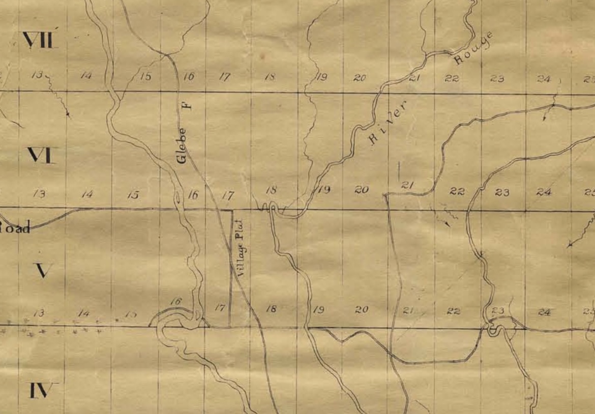
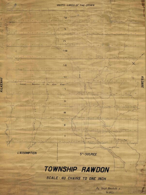
As early as 1821, the map of Rawdon township, drawn by Surveyor Bouchette, identified the location of the future village centre (see Village plat). It is situated on a plateau between the Rouge and Ouareau rivers.
Between 1815 and 1820, several families, mostly Irish, came to settle in Rawdon township. Irish roots are still very much present in the community (5)
Location of the “Village Plat” between the Rouge River and the Ouareau River.
Map of Rawdon township dated 1821 by Surveyor Joseph Bouchette Jr.
Starting in the early 20th century, tourism and vacationing contributed to a significant increase in Rawdon’s population, which had stabilized at around 1,000 people (6). Unofficial figures (7) from the 1970s estimated that Rawdon’s population could triple during vacation and holiday periods. Thus, the population of 4,060 recorded in the 1971 census could rise to as many as 12,000 people when including those staying in its hotels, campgrounds, summer camps and cottages as well as other visitors (8). For example, the Val-Pontbriand-sur-le-lac campground alone could accommodate up to 300 families, or just over a thousand people. In 2026, the municipality has approximately 13,124 residents (9). The proportion of non-residents is lower, however, due to the conversion of cottages and second homes into primary residences.
Several other aspects of Rawdon’s history are presented on the website histoirederawdon.ca.
A collaborative effort
This tour was made possible thanks to the collaboration of several partners and was officially opened during the Canada Day celebrations on July 1, 2026.
Project coordination :
Société d'histoire de Rawdon
Design and research :
Amis et propriétaires riverains du Lac Rawdon et de ses affluents (Friends and property owners along Rawdon Lake and its tributaries)
Manon Lacharité
Pierre Landry
France Pontbriand
Collège Champagneur
Grade 11 students, history class
Rosalie Lafleur-Raymond, history teacher
Création Unimage
Geneviève Champoux
Municipality of Rawdon
Andréanne Goulet
Société d’histoire de Rawdon :
Michel Léonard
France Pontbriand
Studio Julie-Cossette
Julie Cossette
Content contributors
André Neveu
André Tessier, Société d’histoire de Rawdon
Anick Perreault, Rawdon Golf Resort
Benoit Chevrier, Centre d’interprétation de l’eau
Beverly Blagrave Prud’homme
Daniel Parkinson, Société d’histoire de Rawdon
Daniel Rémy, Société d’histoire de Rawdon
Denise Perreault-Breault, Société d’histoire de Rawdon
Diane Mailhot, Société d’histoire de Rawdon
Guillaume Petit, Société d’histoire de Rawdon
Guylène Ethier, Société d’histoire de Rawdon
Hélène Cantin, Société d’histoire de Rawdon
Henri Tessier, Société d’histoire de Rawdon
Luc Bouliane, Municipalité de Rawdon
Michel Roberge, Société d’histoire de Rawdon
Stéphanie Laurent, Municipalité de Rawdon
Language editing and translation
Nathalie Longpré, editing, Société d’histoire de Rawdon
Valérie Dezelac, editing
Victoria Locke, translation, Société d’histoire de Rawdon
Graphic design
Création Unimage
Geneviève Champoux
Julie Cossette Studio
Julie Cossette
For further information:
Email: info@histoirederawdon.ca
Phone: 514-605-6809
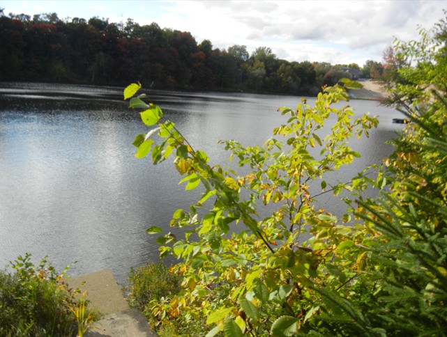
Rawdon Lake and municipal beach, photo : Société d’histoire de Rawdon
Sources
Roy, P.-A., ministère de l’Environnement, de la Lutte contre les Changements climatiques, de la Faune et des Parcs (MELCCFP), Lac Rawdon, comté de Montcalm, Canton de Rawdon, fiche marine officielle 0814.